Caldor Fire, other California blazes shown in satellite imagery
September 01, 2021 at 14:49 PM EDT
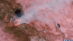

Imagery from NOAA Satellites shows the way smoke is spreading from California wildfires.
Caldor Fire, other California blazes shown in satellite imagerySeptember 01, 2021 at 14:49 PM EDT
Imagery from NOAA Satellites shows the way smoke is spreading from California wildfires.

Data & News supplied by www.cloudquote.io
Stock quotes supplied by Barchart Quotes delayed at least 20 minutes. By accessing this page, you agree to the following Privacy Policy and Terms and Conditions. |
|