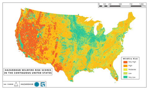
As wildfire season continues to impact California and the western United States, Guidewire (NYSE: GWRE) announced the availability of critical data and maps detailing wildfire risk at the national, state, and local levels. This service leverages more than 1,000 data points and HazardHub risk scores for climate risks and extreme weather events.
This press release features multimedia. View the full release here: https://www.businesswire.com/news/home/20240821791009/en/

HazardHub wildfire risk scores in the contiguous United States. Source: Guidewire HazardHub
Top States for Wildfire Risk
Guidewire HazardHub Enhanced Wildfire Risk Score data indicates that the top states for wildfire risk, based on the percentage of homes receiving an “F” rating for wildfire risk, are:
1. Nevada
2. Oregon
3. California
4. Idaho
5. Wyoming
The HazardHub Enhanced Wildfire Score leverages granular geographical data, updated vegetation data, proximity to fire hydrants and fire stations, historical wildfire data, and environmental factors to provide a detailed and accurate assessment of wildfire risk.
Number of Homes at High Risk from Wildfires
The top states by the number of homes at high risk of wildfire (rated as an “F” for wildfire risk) are:
1. California: 1.03 million homes
2. Oregon: 100k homes
3. Colorado: 64.5k homes
4. Washington: 61.8k homes
5. Arizona: 61.7k homes
According to analysis by Guidewire HazardHub, wildfire risk mitigation and home hardening efforts can reduce the risk of wildfire damage by as much as 70%. By adopting minimal measures, consumers can reduce their risk of wildfire damage by approximately 20%. With more extensive measures, they can reduce their risk by as much as 70%.
Top States for Wildfires
The western U.S. experiences long periods of dry weather, especially during the summer and early fall, which create ideal wildfire conditions. High temperatures, low humidity, and seasonal winds (such as the Santa Ana winds in California) further exacerbate wildfire risks.
The rugged terrain in many western states, such as mountainous regions, can facilitate the spread of wildfires. Steep slopes allow fires to move quickly uphill, and the remote nature of many areas can be a significant challenge for firefighting efforts. In addition, the vegetation found in the western states, including forests, shrublands, and grasslands, is highly flammable.
Historical wildfire data consistently show that the most significant and destructive wildfires tend to occur in the western U.S. Guidewire HazardHub can provide wildfire risk data and maps for all 50 states and Canadian provinces including:
California
In 2023, California experienced 7,127 wildfires of any size, as reported by CalFire, and 329 significant wildfires, as accounted for by the Wildland Fire Interagency Geospatial Service (WFIGS). Over the past decade (2014-2023), California has experienced an average of 203 significant wildfires per year.
The Wildland Fire Interagency Geospatial Services dataset focuses on significant wildfire events, excluding more minor or less impactful incidents. State agencies, such as CalFire, tend to include all reported wildfires within their jurisdiction, including both significant and smaller incidents. Their data tends to be broader and includes more minor events.
According to a Guidewire HazardHub analysis, in California, 98% of wildfire property damage occurs in the 10% of homes rated as "F" for wildfire risk. Homes in these "F" rated areas are approximately 40 times more likely to suffer damage compared to homes in other areas of the state.
Texas
In 2023, Texas experienced 7,530 wildfires of any size, as reported by the Texas A&M Forest Service, and 1,139 significant wildfires, as accounted for by the Wildland Fire Interagency Geospatial Service (WFIGS). Over the past decade (2014-2023), according to WFIGS, Texas has experienced an average of 217.3 significant wildfires per year. Due to its large size, Texas has a high number of wildfires; however, these fires are often more rural, resulting in a lower concentration of risk and fewer homes exposed compared to other western states like California, Oregon, and Nevada.
"Homeowners should aim to better understand their wildfire risk to inform their insurance coverage needs and implement effective mitigation strategies. Efforts such as creating a defensible space, and retrofitting homes with fire-resistant materials, windows, and vents can boost a home's resilience by as much as 40% and help make insurance more affordable. Proactive mitigation is essential for safeguarding homes and contributing to a more resilient community and future," said Tammy Nichols Schwartz, CPCU and Senior Director of Data and Analytics at Guidewire. Schwartz has more than 25 years of experience in the property and casualty insurance industry and is recognized as a wildfire risk expert.
The Enhanced Wildfire Score and other detailed HazardHub data and risk scores are accessible to insurers through Guidewire’s apps, including PolicyCenter and InsuranceNow, and via the HazardHub API. Consumers interested in learning about their home’s risks can visit freehomerisk.com.
About Guidewire
Guidewire is the platform P&C insurers trust to engage, innovate, and grow efficiently. We combine digital, core, analytics, and machine learning to deliver our platform as a cloud service. More than 540 insurers in 40 countries, from new ventures to the largest and most complex in the world, run on Guidewire.
As a partner to our customers, we continually evolve to enable their success. We are proud of our unparalleled implementation track record, with 1,600+ successful projects, supported by the largest R&D team and partner ecosystem in the industry. Our marketplace provides hundreds of applications that accelerate integration, localization, and innovation.
For more information, please visit www.guidewire.com and follow us on X (formerly known as Twitter) and LinkedIn.
View source version on businesswire.com: https://www.businesswire.com/news/home/20240821791009/en/
Contacts
For more information and customized maps:
Melissa Cobb, Senior Public Relations Manager
Guidewire Software
+1 650-464-1177
mcobb@guidewire.com
climate@guidewire.com