VANCOUVER, BC / ACCESS Newswire / June 19, 2025 / Faraday Copper Corp. ("Faraday" or the "Company") (TSX:FDY)(OTCQX:CPPKF) is pleased to announce the results of the final nine drill holes from its Phase III drill program at the Copper Creek Project, located in Arizona ("Copper Creek"). Five holes were drilled in the American Eagle area, one at Old Reliable, two at the Sunrise Trend and one at Horsecamp.
Paul Harbidge, President and CEO, commented, "These final drill results from the Phase III program have continued to expand the near-surface mineralization in the American Eagle area, including at the recently discovered Winchester breccia. We have now commenced work on an updated Mineral Resource Estimate, with an emphasis on expanding the open pit inventory. This work will support an updated Preliminary Economic Assessment with the goal of significantly enhancing the project economics."
"We continue to see excellent exploration results at the project. Surface sampling and a reconnaissance drill hole at the Sunrise Trend have highlighted the potential for a new porphyry system. Across the property there are multiple untested breccias, which crop out at surface and we are excited to continue to unlock value with our next phase of drilling."
Highlights
At the newly-discovered blind Winchester breccia, intersected 45.64 metres ("m") at 0.71% copper from 166.25 m, within 110.80 m at 0.40% copper from 148.74 m in drill hole FCD-25-113.
At the Boomerang breccia and the western extent of Banjo, intersected 60.39 m at 0.43% copper from 206.65 m, including 17.75 m at 1.04% copper from 242.94 m in drill hole FCD-25-115.
Near the Banjo breccia, intersected 48.40 m at 0.39% copper from 58.33 m, including 17.30 m at 0.63% copper from 80.00 m in drill hole FCD-25-105. Mineralization in this hole is largely contained in porphyry-style veins.
-
A reconnaissance hole at the Sunrise Trend (FCD-25-116), identified a previously undrilled copper mineralized porphyry system, intersecting 57.98 m at 0.23% copper from 1,029.21 m, including 15.21 m at 0.43% copper from 1,035.91 m.
Hole FCD-25-116 is interpreted to have intersected the eastern margin of a potentially larger mineral system. Ongoing geological mapping and preliminary geochemical results are encouraging and highlight the prospectivity of the Sunrise Trend in the southern part of the Western Breccia Trend. Follow-up drill planning is underway for these areas.
(For true width information see Table 1)
Phase III Drill Program - Summary
Phase III drilling commenced in October 2023 and concluded in mid-April 2025. With this news release, all 79 drill hole assays have been reported. For drill holes not reported herein, refer to news releases on the Company's website and SEDAR+ profile at www.sedarplus.ca.
34 holes were drilled in the American Eagle area, discovering numerous mineralized breccias, including the discovery hole at the Banjo breccia which intersected 117.90 m at 1.01% copper. All drilling in this area intersected reportable intervals of copper mineralization above cut-off grade1 near-surface. The American Eagle area will be a continued focus of future drilling and the Company expects to declare an inaugural open pit mineral resource in this area as part of the 2025 Mineral Resource Estimate ("MRE") update.
13 holes were drilled in Area 51, which is expected to support a small open pit mineral resource with follow up drilling planned. A number of breccias were discovered in this area.
24 holes were drilled near the current mineral resource with the goal of expanding mineralization, increasing confidence in drill data, and providing geotechnical and hydrological information.
8 additional reconnaissance holes were drilled in areas including Horsecamp and the Sunrise Trend.
Next Steps
The Company has completed nearly 40,000 metres of incremental drilling beyond the current MRE2, which represents a significant opportunity to enhance the project value by increasing the open pit mineral resource.
The Company anticipates the release of an updated MRE and Preliminary Economic Assessment ("PEA") near the end of the third quarter of 2025.
Drill Hole Summary
The American Eagle area, as mapped on surface, covers approximately 800 m by 1,000 m and is host to numerous prospective breccias and porphyries which have strong copper geochemical signatures (Figures 1 and 2). These surface expressions locate above the large underground porphyry mineral resource1, which is approximately 500 m to 1,100 m depth below surface. Historically, the near-surface mineralization was not adequately tested as previous drilling was vertical to steeply inclined. Mapped geology, isolated historical drill intercepts and historical small-scale mining highlight the potential for near-surface mineralization. This, together with assay results from Phase III drilling, provides a broad framework of the geology, structure, and alteration and confirms the potential for significant near-surface copper mineralization.
Drill hole FCD-25-103 is collared approximately 20 m northwest from the Banjo breccia and drilled to the northwest. The hole intersected granodiorite for its entire length with the exception of a narrow interval of hydrothermal breccia from 483 m to 487 m. Alteration is generally subtle and includes weak background biotite and potassium feldspar. Kaolinite together with sericite associated with porphyry style veins and overprinting weak potassic alteration was identified from approximately 130 m to 240 m. Locally intense sericitic alteration is observed around the hydrothermal breccia interval. Mineralization occurs as chalcopyrite together with pyrite in porphyry-style veins and locally as breccia cement.
Drill hole FCD-25-105 is collared 100 m southeast of the Banjo breccia and drilled to the northwest. It intersected granodiorite for the entire hole, except for hydrothermal breccia from 99 m to 103 m and 169 m to 189 m. Alteration associated with breccia and surrounding granodiorite is sericitic. Sericite-kaolinite is associated with porphyry-style veins crosscutting granodiorite, which is affected by subtle background potassic alteration. Mineralization occurs as chalcocite with chalcopyrite and pyrite in porphyry-style veins within the first 120 m of the hole. Chalcopyrite occurs together with pyrite in porphyry-style veins and, locally, breccia cement in the remainder of the hole.
Drill hole FCD-25-108 is collared approximately 20 m south of the Jailhouse breccia and drilled to the southeast. It intersected hydrothermal breccia from 7 m to 19 m and granodiorite for the remainder of the hole. Alteration is associated with porphyry-style veins and includes sericite-kaolinite overprinting subtle potassic alteration. Mineralization occurs as chalcopyrite with pyrite in porphyry-style veins.
Drill hole FCD-25-113 is collared approximately 20 m south of the Jailhouse breccia and was drilled to the south. Hydrothermal breccia dominates the first 75 m of the hole, followed by granodiorite to 111 m and porphyry to 134 m. Hydrothermal breccia is the dominant lithology for the remainder of the hole. Alteration is sericitic near the top of the hole whereas in the lower breccia domain, potassic alteration overprinted by sericite is dominant. Mineralization occurs as chalcopyrite together with pyrite and minor tourmaline in breccia cement. Trace amounts of bornite occur locally.
Drill hole FCD-25-115 is collared between the Boomerang and Prada breccias and drilled to the north. It starts in hydrothermal breccia and enters granodiorite at 56 m. Additional breccia intersections are present from 164 m to 181 m and 243 m to 269 m, whereas granodiorite is the dominant lithology outside the breccias. Alteration is quartz-sericite affecting breccias and zones with abundant porphyry-style veining. Tourmaline is present within breccias. Mineralization occurs as chalcopyrite together with pyrite in breccia cement and porphyry-style veins.
The Sunrise Trend hosts the historical Bunker Hill mine, which is located 1.2 km south of American Eagle and 1 km west of Area 51 (Figure 1). The mine exploited a polymetallic lead-zinc-silver-copper vein in the early 20th century. Airborne short-wave infrared spectral data, together with a strong Induced Polarization ("IP") geophysical anomaly, geological mapping and rock chip sampling, highlight the exploration potential of the area. The data suggest the historically mined vein is related to a porphyry centre separate from the American Eagle and Mammoth - Keel systems at Copper Creek. Modern exploration and drilling are limited in the area. Two reconnaissance holes were drilled to guide further exploration.
Drill hole FCD-25-114 is collared approximately 400 m east of the Bunker Hill mine and was drilled to the south. It starts and ends in Glory Hole volcanics and intercepted several hydrothermal breccia zones including from 39 m to 53 m, 150 m to159 m, 162 m to 206 m and 248 m to 322 m. The Glory Hole volcanics are variably chlorite-sericite altered whereas breccia zones are characterized by intense sericite alteration. Breccias contain pyrite cement. From 210 m to 218 m, a vein zone with chalcopyrite, tetrahedrite and galena and high silver grades was intersected.
Drill hole FCD-25-116 is collared at the same location as hole FCD-25-114 and drilled to the southwest. In addition to testing the geophysical anomaly, three piezometers for monitoring the hydrogeologic conditions were installed in this drill hole. Glory Hole volcanics dominate to 816 m, while hydrothermal breccia zones are present from 67 m to 131 m and 653 m to 686 m. From 816 m to 1,087 m, igneous breccia with variably intense hydrothermal overprint is present. Granodiorite, as clasts in breccia and short drill intercepts is observed below approximately 1,038 m. The drill hole ends in granodiorite. Alteration in the upper half of this hole is similar to that observed in hole FCD-24-114. Secondary biotite and K-feldspar increases downward. Below 950 m, potassic alteration with K-feldspar, secondary biotite and magnetite is dominant, except for some breccia zones affected by a sericitic overprint. Chalcopyrite is observed below 900 m and occurs in veinlets, disseminated and as breccia cement. Locally, bornite is also present. From 558 m to 601 m, a fault zone containing galena and elevated silver, is observed.
Old Reliable is a historical mine, approximately 700 m west of Mammoth, where high-grade breccia-hosted mineralization was mined via surface blasting. Geophysical data highlight a zone of low resistivity extending westward at depth from Keel to below Old Reliable.
Drill hole FCD-25-098A is collared 100 m east of the Old Reliable breccia and was drilled to the southwest, testing a low resistivity geophysical anomaly. Three piezometers for monitoring the hydrogeological conditions were installed. The hole intersected dominantly granodiorite except for a diorite from 268 m to 321 m and igneous cemented breccia with variable hydrothermal overprint from 343 m to 428 m. Breccia clasts are mostly granodiorite, but include intensely K-feldspar altered granodiorite, quartz and anhydrite. Background alteration is potassic with biotite and K-feldspar, but sericitic alteration is observed in the breccia zone. Prehnite, which has also been identified near the Keel cupola zone, is present below 750 m. Mineralization is present in the breccia domain and isolated porphyry-style veinlets. Chalcopyrite together with molybdenite and minor bornite occurs disseminated, as breccia cement and veinlets. The breccia is interpreted as brecciated cupola zone, which suggests exploration potential below Old Reliable.
The Horsecamp area is part of the Western Breccia Trend and is located approximately 1 km to 1.5 km southwest of the Rum area (Figure 1). The trend extends over 5 km in a northwesterly orientation approximately 1 km to 2 km west of the resource area. It includes over 50 breccias intruding Glory Hole volcanics and granodiorite. Historical and current drilling along the trend is limited. The alteration and sulphide assemblages, together with geologic relationships suggest that shallow parts of these breccias are preserved, and copper mineralization may be present at depth. In the Horsecamp area several hydrothermal breccias and a vein zone with copper mineralization potential at depth crop out and are visible at surface.
Drill hole FCD-24-096 is collared in the Horsecamp area, approximately 1 km southwest of Rum and drilled to the south. It intersected granodiorite with breccia zones present at 86 m to 95 m, 114 m to 124 m, 145 m to 164 m, 191 m to 230 m, and 355 m to 376 m. Alteration associated with breccia zones is sericite-kaolinite with local presence of pyrophyllite. Potassic alteration with K-feldspar and biotite affects the granodiorite outside the breccias, most prominently below 230 m. Pyrite is the dominant sulphide and occurs as breccia cement and in D-type porphyry veinlets. The alteration associated with breccia suggests that the drill intercept represents a shallow part of a potentially mineralized system and exploration potential exists at depth.
Figure 1: Plan View Showing Surface Geology and Location of the Drill Holes
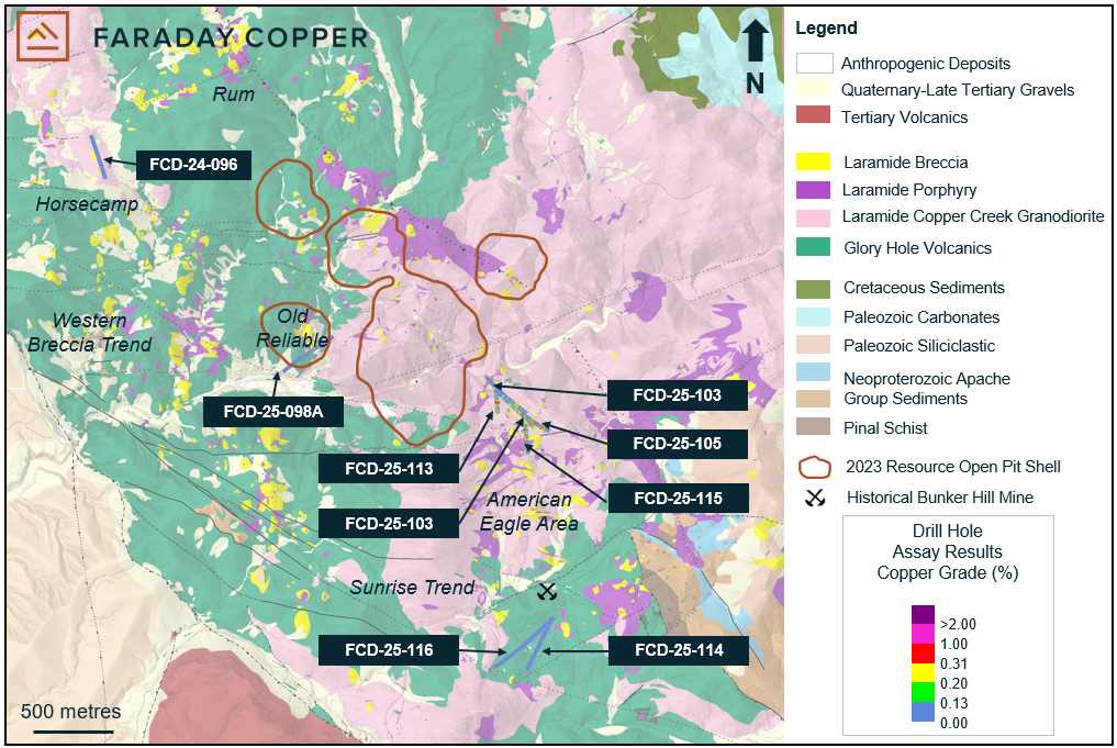
Note: The open pit shells are based on constraints used in the MRE as presented in the Copper Creek Technical Report2.
Figure 2: Isometric View Showing Phase III Drill Holes in the American Eagle Area
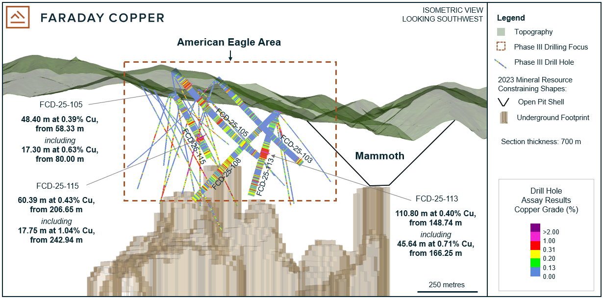
Note: The open pit shell and underground footprint are based on constraints used in the MRE as presented in the Copper Creek Technical Report2. For drill holes not reported herein, refer to news releases on the Company's website at www.faradaycopper.com and on the Company's SEDAR+ profile at www.sedarplus.ca.
Table 1: Selected Drill Results
Drill Hole ID |
From |
To |
Length |
True Width |
Cu |
Au |
Ag |
Mo |
|
(m) |
(m) |
(m) |
(m) |
(%) |
(g/t) |
(g/t) |
(%) |
FCD-25-098A |
314.76 |
334.42 |
19.66 |
8 |
0.17 |
N/A |
1.09 |
0.0196 |
and |
362.42 |
369.00 |
33.58 |
14 |
0.11 |
N/A |
0.45 |
0.0383 |
and |
472.45 |
492.59 |
20.14 |
9 |
0.18 |
N/A |
0.63 |
0.0031 |
FCD-25-103 |
65.00 |
72.31 |
7.31 |
7 |
0.35 |
N/A |
0.85 |
0.0008 |
and |
100.63 |
152.67 |
52.04 |
52 |
0.17 |
N/A |
0.52 |
0.0003 |
and |
470.22 |
499.14 |
28.92 |
28 |
0.23 |
N/A |
0.59 |
0.0018 |
FCD-25-105 |
58.33 |
106.73 |
48.40 |
48 |
0.39 |
N/A |
0.92 |
0.0006 |
Including |
80.00 |
97.30 |
17.30 |
17 |
0.63 |
N/A |
0.91 |
0.0004 |
and |
162.42 |
231.50 |
69.08 |
69 |
0.27 |
N/A |
1.05 |
0.0022 |
and |
263.90 |
296.10 |
32.20 |
32 |
0.28 |
N/A |
0.70 |
0.0008 |
and |
323.61 |
386.73 |
63.12 |
63 |
0.16 |
N/A |
0.41 |
0.0008 |
and |
412.87 |
429.25 |
16.38 |
16 |
0.26 |
N/A |
0.66 |
0.0010 |
FCD-25-108 |
83.29 |
136.47 |
52.98 |
52 |
0.17 |
N/A |
0.46 |
0.0004 |
and |
158.73 |
201.12 |
42.39 |
42 |
0.17 |
N/A |
0.37 |
0.0005 |
and |
215.20 |
239.27 |
24.07 |
24 |
0.15 |
N/A |
0.38 |
0.0008 |
and |
261.50 |
348.54 |
86.67 |
86 |
0.26 |
N/A |
0.57 |
0.0043 |
and |
364.76 |
380.61 |
15.85 |
15 |
0.23 |
N/A |
0.45 |
0.0012 |
and |
426.23 |
442.24 |
16.01 |
16 |
0.24 |
N/A |
0.64 |
0.0004 |
and |
458.65 |
502.19 |
43.54 |
43 |
0.19 |
N/A |
0.46 |
0.0011 |
FCD-25-113 |
44.50 |
75.52 |
31.02 |
13 |
0.16 |
N/A |
0.62 |
0.0022 |
and |
148.74 |
259.54 |
110.80 |
47 |
0.40 |
0.01 |
1.00 |
0.0008 |
Including |
166.25 |
211.89 |
45.64 |
19 |
0.71 |
0.02 |
1.27 |
0.0008 |
FCD-25-114 |
210.61 |
218.18 |
7.57 |
5 |
0.54 |
N/A |
26.32 |
0.0002 |
FCD-25-115 |
39.91 |
112.18 |
72.27 |
72 |
0.18 |
N/A |
0.96 |
0.0014 |
and |
140.48 |
182.94 |
42.46 |
26 |
0.27 |
N/A |
0.73 |
0.0018 |
and |
206.65 |
267.04 |
60.39 |
37 |
0.43 |
N/A |
1.39 |
0.0010 |
Including |
242.94 |
260.69 |
17.75 |
11 |
1.04 |
N/A |
2.82 |
0.0012 |
and |
311.47 |
347.96 |
36.49 |
36 |
0.22 |
N/A |
0.62 |
0.0009 |
FCD-25-116 |
1,029.21 |
1,087.10 |
57.98 |
57 |
0.23 |
N/A |
0.57 |
0.0005 |
Including |
1,035.91 |
1,051.12 |
15.21 |
15 |
0.43 |
N/A |
0.99 |
0.0005 |
FCD-24-096 |
No significant results |
|||||||
Note: All intercepts are reported as downhole drill widths. Mineralization includes bulk porphyry style and breccia mineralization. True widths are approximate due to the irregular shape of mineralized domains. N/A: Not analyzed.
Table 2: Collar Locations from the Drill Holes Reported Herein
Drill Hole ID |
Easting |
Northing |
Elevation |
Azimuth |
Dip |
Target |
Depth |
Depth |
|
|
|
(m) |
(°) |
(°) |
|
(ft) |
(m) |
FCD-24-096 |
546374 |
3625264 |
1,308 |
162 |
45 |
Horsecamp |
1,308.1 |
429.16 |
FCD-25-098A |
547895 |
3624017 |
1,170 |
235 |
65 |
Old Reliable Deep |
2,850.3 |
935.13 |
FCD-25-103 |
549115 |
3623533 |
1,338 |
310 |
45 |
American Eagle North |
1,525.3 |
500.42 |
FCD-25-105 |
549255 |
3623431 |
1,370 |
300 |
50 |
Banjo |
1,551.5 |
509.02 |
FCD-25-108 |
548897 |
3623673 |
1,216 |
135 |
45 |
American Eagle North |
1,530.7 |
502.19 |
FCD-25-113 |
548904 |
3623670 |
1,216 |
175 |
65 |
Winchester |
1,147.7 |
376.53 |
FCD-25-114 |
549267 |
3622258 |
1,320 |
208 |
45 |
Sunrise |
1,744.7 |
572.41 |
FCD-25-115 |
549126 |
3623278 |
1,295 |
356 |
52 |
Boomerang |
1,060.6 |
347.96 |
FCD-25-116 |
549268 |
3622257 |
1,320 |
228 |
59 |
Sunrise |
3,417.0 |
1,121.05 |
Note: Coordinates are given as World Geodetic System 84, Universal Transverse Mercator Zone 12 north (WGS84, UTM12N).
Sampling Methodology, Chain of Custody, Quality Control and Quality Assurance
All sampling was conducted under the supervision of the Company's geologists and the chain of custody from Copper Creek to the independent sample preparation facility, ALS Laboratories in Tucson, AZ, was continuously monitored. The samples were taken as ½ core, over 2 m core length. Samples were crushed, pulverized and sample pulps were analyzed using industry standard analytical methods including a 4-Acid ICP-MS multielement package and an ICP-AES method for high-grade copper samples. Gold was analyzed on a 30 g aliquot by fire assay with an ICP-AES finish. A certified reference sample was inserted every 20th sample. Coarse and fine blanks were inserted every 20th sample. Approximately 5% of the core samples were cut into ¼ core and submitted as field duplicates. On top of internal QA-QC protocol, additional blanks, reference materials and duplicates were inserted by the analytical laboratory according to their procedure. Data verification of the analytical results included a statistical analysis of the standards and blanks that must pass certain parameters for acceptance to ensure accurate and verifiable results.
Qualified Person
The scientific and technical information contained in this news release has been reviewed and approved by Faraday's VP Exploration, Dr. Thomas Bissig, P. Geo., who is a Qualified Person under National Instrument 43-101 - Standards of Disclosure for Mineral Projects ("NI 43-101").
Notes
1 Copper cutoff grade is as presented in the MRE2.
2 The Mineral Resource Estimate is presented in the report titled "Copper Creek Project NI 43-101 Technical Report and Preliminary Economic Assessment" with an effective date of May 3, 2023, available on the Company's website at www.faradaycopper.com and on the Company's SEDAR+ profile at www.sedarplus.ca.
About Faraday Copper
Faraday Copper is an exploration company focused on advancing its flagship copper project in Arizona, U.S. The Copper Creek Project is one of the largest undeveloped copper projects in North America with significant district scale exploration potential. The Company is well-funded to deliver on its key milestones and benefits from a management team and board of directors with senior mining company experience and expertise. Faraday trades on the TSX under the symbol "FDY".
For additional information please contact:
Stacey Pavlova, CFA
Vice President, Investor Relations & Communications
Faraday Copper Corp.
E-mail: info@faradaycopper.com
Website: www.faradaycopper.com
To receive news releases by e-mail, please register using the Faraday website at www.faradaycopper.com.
Cautionary Note on Forward Looking Statements
Some of the statements in this news release, other than statements of historical fact, are "forward-looking statements" and are based on the opinions and estimates of management as of the date such statements are made and are necessarily based on estimates and assumptions that are inherently subject to known and unknown risks, uncertainties and other factors that may cause actual results, level of activity, performance or achievements of Faraday to be materially different from those expressed or implied by such forward-looking statements. Such forward-looking statements and forward-looking information specifically include, but are not limited to, statements concerning the exploration potential of the Copper Creek property and the timing of the MRE and PEA.
Although Faraday believes the expectations expressed in such forward-looking statements are based on reasonable assumptions, such statements should not be in any way construed as guarantees of future performance and actual results or developments may differ materially. Accordingly, readers should not place undue reliance on forward-looking statements or information.
Factors that could cause actual results to differ materially from those in forward-looking statements include without limitation: market prices for metals; the conclusions of detailed feasibility and technical analyses; lower than expected grades and quantities of mineral resources; receipt of regulatory approval; receipt of shareholder approval; mining rates and recovery rates; significant capital requirements; price volatility in the spot and forward markets for commodities; fluctuations in rates of exchange; taxation; controls, regulations and political or economic developments in the countries in which Faraday does or may carry on business; the speculative nature of mineral exploration and development, competition; loss of key employees; rising costs of labour, supplies, fuel and equipment; actual results of current exploration or reclamation activities; accidents; labour disputes; defective title to mineral claims or property or contests over claims to mineral properties; unexpected delays and costs inherent to consulting and accommodating rights of Indigenous peoples and other groups; risks, uncertainties and unanticipated delays associated with obtaining and maintaining necessary licenses, permits and authorizations and complying with permitting requirements, including those associated with the Copper Creek property; and uncertainties with respect to any future acquisitions by Faraday. In addition, there are risks and hazards associated with the business of mineral exploration, development and mining, including environmental events and hazards, industrial accidents, unusual or unexpected formations, pressures, cave-ins, flooding and the risk of inadequate insurance or inability to obtain insurance to cover these risks as well as "Risk Factors" included in Faraday's disclosure documents filed on and available at www.sedarplus.ca.
This press release does not constitute an offer to sell or a solicitation of an offer to buy any securities in any jurisdiction to any person to whom it is unlawful to make such an offer or solicitation in such jurisdiction. This press release is not, and under no circumstances is to be construed as, a prospectus, an offering memorandum, an advertisement or a public offering of securities in Faraday in Canada, the United States or any other jurisdiction. No securities commission or similar authority in Canada or in the United States has reviewed or in any way passed upon this press release, and any representation to the contrary is an offence.
SOURCE: Faraday Copper Corp.
View the original press release on ACCESS Newswire