ETFOptimize | High-performance ETF-based Investment Strategies

Quantitative strategies, Wall Street-caliber research, and insightful market analysis since 1998.


ETFOptimize | HOME
Close Window

Dangerous storms result in flash flooding, severe weather over Southern Plains

More life-threatening severe weather is expected over the Southern Plains, following reports of twisters ripping through the nation's heartland on Friday.

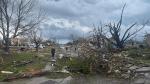
Additional rounds of life-threatening severe weather are likely over the Southern Plains, after twisters ripped through the nation's heartland on Friday. In addition, confidence is increasing for flash flooding in parts of east-central Oklahoma where 5-10 inches of rain may fall through Sunday. Over 50 million people are under threat of severe weather as the atmosphere recharges, stretching more than 1,500 miles from the Gulf Coast to the Great Lakes.

The greatest threat for tornadoes on Saturday stretched from Oklahoma through the Upper Mississippi Valley but is expected to slide eastward on Sunday.

Due to the risk, the NWS office in Norman, Oklahoma, launched a special weather balloon on Saturday afternoon to help survey the atmosphere to determine if storms would be able to blossom during the evening.

The Storm Prediction Center received over 100 reports of severe weather on Saturday, with most being of large hail, but several tornadoes were spotted in Kansas and Oklahoma.

TORNADO TEARS THROUGH OMAHA

The severe weather threat is expected to wane into Sunday, but still presents a widespread risk of additional storms across the Mississippi Valley. A Level 2 severe weather threat covers over 20 million people from Austin and Dallas in Texas to southeastern Iowa and western Illinois.

Once again, tornadoes, large hail and damaging wind gusts are all in play, but the storms are not expected to be as intense as on Friday.

If tornadoes, hail and wind were not enough, much of the Southern Plains is also at a significant risk of flash flooding into Sunday.

Thunderstorms may be slow movers or stall, leading to multiple inches of rain to fall on the same areas and significant flooding.

WATCH: TORNADOES TEAR ACROSS AMERICA'S HEARTLAND, LEAVING CATASTROPHICM DESTRUCTION IN MULTIPLE STATES

NOAA’s Weather Prediction Center has now put parts of Oklahoma along the Interstate 40 corridor east of Oklahoma City in a Level 4 out of 4 flash flood risk into Sunday morning.

24-hour rainfall totals in the Level 4 flash flooding risk zone may approach or exceed 10 inches, forecasters said. But even 3-6 inches or more and flash flooding is expected from the Red River Valley into much of Oklahoma, including Oklahoma City and Tulsa.

"High" risks for flash flooding are only issued on about 4% of days (including tropical and non-tropical events), but this risk category accounts for 39% of flood-related fatalities and 83% of flood-related damages in the continental U.S., according to research by WPC meteorologists. What's more, 46% of high-risk flood days have at least one fatality or injury, and 62% of such days have at least $1 million in damages, Greg Carbin, forecast operations branch chief at the WPC, noted in the research.

Data & News supplied by www.cloudquote.io
Stock quotes supplied by Barchart
Quotes delayed at least 20 minutes.
By accessing this page, you agree to the following
Privacy Policy and Terms and Conditions.


IntelligentValue Home
Close Window

DISCLAIMER

All content herein is issued solely for informational purposes and is not to be construed as an offer to sell or the solicitation of an offer to buy, nor should it be interpreted as a recommendation to buy, hold or sell (short or otherwise) any security.  All opinions, analyses, and information included herein are based on sources believed to be reliable, but no representation or warranty of any kind, expressed or implied, is made including but not limited to any representation or warranty concerning accuracy, completeness, correctness, timeliness or appropriateness. We undertake no obligation to update such opinions, analysis or information. You should independently verify all information contained on this website. Some information is based on analysis of past performance or hypothetical performance results, which have inherent limitations. We make no representation that any particular equity or strategy will or is likely to achieve profits or losses similar to those shown. Shareholders, employees, writers, contractors, and affiliates associated with ETFOptimize.com may have ownership positions in the securities that are mentioned. If you are not sure if ETFs, algorithmic investing, or a particular investment is right for you, you are urged to consult with a Registered Investment Advisor (RIA). Neither this website nor anyone associated with producing its content are Registered Investment Advisors, and no attempt is made herein to substitute for personalized, professional investment advice. Neither ETFOptimize.com, Global Alpha Investments, Inc., nor its employees, service providers, associates, or affiliates are responsible for any investment losses you may incur as a result of using the information provided herein. Remember that past investment returns may not be indicative of future returns.

Copyright © 1998-2017 ETFOptimize.com, a publication of Optimized Investments, Inc. All rights reserved.