Recent Quotes View Full List My Watchlist Create Watchlist Indicators DJI Nasdaq Composite SPX Gold Crude Oil EL&P Market Index Markets Stocks ETFs Tools Overview News Currencies International Treasuries Camino Commences Mapping and Drone Geophysics Survey with Nittetsu at the Los Chapitos Project, Peru By: ACCESSWIRE July 26, 2023 at 06:00 AM EDT VANCOUVER, BC / ACCESSWIRE / July 26, 2023 / Camino Corp. (TSXV:COR)(OTC PINK:CAMZF)(WKN:A116E1) ("Camino" or the "Company"), together with its project partner Nittetsu Mining Co. Ltd ("Nittetsu"), is pleased to announce that its mapping campaign and drone geophysics survey is underway at the Los Chapitos copper project ("Los Chapitos" or the "Project"). The campaign will focus on copper mineralized structures next to porous geological strata that could host bulk manto-style copper mineralization for follow up exploration drilling. The exploration methodology follows the same geology and geometry of other manto discoveries at Los Chapitos, such as Adriana, Lourdes, and Atajo, to add additional mineral inventory to the Los Chapitos project. Highlights: Geological mapping at a scale of 1:25000 covering 20,445 hectares, emphasizing the understanding of structural geology. Topographic survey covering 15,681 hectares. Drone magnetic geophysical survey covering 5,595 hectares. Picture 1. Topographic survey with WINGTRA Drone with high resolution image capture. "There are many copper outcrop occurrences over the Los Chapitos property, and we have had success at drilling bulk tonnage copper mantos at several copper outcrops such as Adriana and Lourdes", said Jay Chmelauskas, CEO of Camino. "With new geophysics surveys and geology mapping we plan to be more targeted with copper outcrop drilling, and to extend our exploration targets to potential buried copper manto layers. Our overall goal is to add more copper mineralized inventory in the form of additional copper mantos at Los Chapitos." Felix Cornelio, Chief Geologist at Camino stated: "Our 2023 exploration campaign is tapping the experience gained in modelling the copper mantos discovered at Adriana and Lourdes and applying that knowledge to find more copper mantos across the Project. Copper mineralization at Los Chapitos is controlled by geological faults. When a mineralized fault is in contact with a porous geological layer, a bulk tonnage strata-bound copper manto can form in the layer. Thus, we are identifying these geological conditions as targets for our next drilling campaign." The Camino geological team has developed an exploration program that involves a series of geological and geophysical surveys covering 20,445 hectares across the Project's mining concessions. The exploration program will be implemented through geological mapping at a scale of 1:25000 covering the entire Los Chapitos Project area (Figure 1). This work will establish the relationships between faults, host rocks, identification of intrusives, hydrothermal alterations, and styles of mineralization. The purpose is to define prospective zones that could host new mineralized bodies. Figure 1. Los Chapitos Project Area. In parallel to the geological mapping, a topographic survey with drones covering 15,681 hectares and a magnetic geophysical survey covering the NW part of the Project with a total of 5,595 hectares in the North sector of the Atajo Trend will be carried out (Figure 2). Figure 2. Work areas for high-resolution imaging (blue) and proposed magnetometry study (red). About Camino CorporationCamino is a discovery and development stage copper exploration company. The Company is focused on advancing its high-grade Los Chapitos copper project located in Peru through to resource delineation and to add new discoveries. Camino has also permitted the Maria Cecilia copper porphyry project for a planned exploration drilling program. In addition, the Company has increased its land position at its copper and silver Plata Dorada project. The Company seeks to acquire a portfolio of advanced copper assets that have the potential to deliver copper into an electrifying copper intensive global economy. For more information, please refer to Camino's website at www.caminocorp.com. Jose A. Bassan, FAusIMM (CP) 227922, MSc. Geologist, an independent geologist and a Qualified Person as defined by National Instrument 43-101 - Standards of Disclosure for Mineral Projects, has reviewed and approved the technical information in this document. Mr. Bassan has reviewed and verified relevant data supporting the technical information, including sampling and analytical test data. ON BEHALF OF THE BOARD For further information, please contact: /S/ "Jay Chmelauskas" Camino Investor Relations President and CEO info@caminocorp.com Tel: (604) 493-2058 Neither TSX Venture Exchange nor its Regulation Services Provider (as that term is defined in the policies of the TSX Venture Exchange) accepts responsibility for the adequacy or accuracy of this release. Cautionary Note Regarding Forward-Looking Statements: Certain disclosures in this release constitute forward-looking information. In making the forward-looking disclosures in this release, the Company has applied certain factors and assumptions that are based on the Company's current beliefs as well as assumptions made by and information currently available to the Company. Forward-looking information in the release includes the prospectivity of future exploration work at Los Chapitos. Although the Company considers these assumptions to be reasonable based on information currently available to it, they may prove to be incorrect, and the forward-looking information in this release is subject to numerous risks, uncertainties and other factors that may cause future results to differ materially from those expressed or implied in such forward-looking information. Such risk factors include, among others, that actual results of the Company's exploration activities will be different than those expected by management, that the Company will be unable to obtain or will experience delays in obtaining any required approvals and the state of equity and commodity markets. Readers are cautioned not to place undue reliance on forward-looking statements. The Company does not intend, and expressly disclaims any intention or obligation to, update or revise any forward-looking statements whether as a result of new information, future events or otherwise, except as required by law. SOURCE: Camino Minerals Corp. View source version on accesswire.com: https://www.accesswire.com/770302/Camino-Commences-Mapping-and-Drone-Geophysics-Survey-with-Nittetsu-at-the-Los-Chapitos-Project-Peru Data & News supplied by www.cloudquote.io Stock quotes supplied by Barchart Quotes delayed at least 20 minutes. By accessing this page, you agree to the following Privacy Policy and Terms and Conditions.
Camino Commences Mapping and Drone Geophysics Survey with Nittetsu at the Los Chapitos Project, Peru By: ACCESSWIRE July 26, 2023 at 06:00 AM EDT VANCOUVER, BC / ACCESSWIRE / July 26, 2023 / Camino Corp. (TSXV:COR)(OTC PINK:CAMZF)(WKN:A116E1) ("Camino" or the "Company"), together with its project partner Nittetsu Mining Co. Ltd ("Nittetsu"), is pleased to announce that its mapping campaign and drone geophysics survey is underway at the Los Chapitos copper project ("Los Chapitos" or the "Project"). The campaign will focus on copper mineralized structures next to porous geological strata that could host bulk manto-style copper mineralization for follow up exploration drilling. The exploration methodology follows the same geology and geometry of other manto discoveries at Los Chapitos, such as Adriana, Lourdes, and Atajo, to add additional mineral inventory to the Los Chapitos project. Highlights: Geological mapping at a scale of 1:25000 covering 20,445 hectares, emphasizing the understanding of structural geology. Topographic survey covering 15,681 hectares. Drone magnetic geophysical survey covering 5,595 hectares. Picture 1. Topographic survey with WINGTRA Drone with high resolution image capture. "There are many copper outcrop occurrences over the Los Chapitos property, and we have had success at drilling bulk tonnage copper mantos at several copper outcrops such as Adriana and Lourdes", said Jay Chmelauskas, CEO of Camino. "With new geophysics surveys and geology mapping we plan to be more targeted with copper outcrop drilling, and to extend our exploration targets to potential buried copper manto layers. Our overall goal is to add more copper mineralized inventory in the form of additional copper mantos at Los Chapitos." Felix Cornelio, Chief Geologist at Camino stated: "Our 2023 exploration campaign is tapping the experience gained in modelling the copper mantos discovered at Adriana and Lourdes and applying that knowledge to find more copper mantos across the Project. Copper mineralization at Los Chapitos is controlled by geological faults. When a mineralized fault is in contact with a porous geological layer, a bulk tonnage strata-bound copper manto can form in the layer. Thus, we are identifying these geological conditions as targets for our next drilling campaign." The Camino geological team has developed an exploration program that involves a series of geological and geophysical surveys covering 20,445 hectares across the Project's mining concessions. The exploration program will be implemented through geological mapping at a scale of 1:25000 covering the entire Los Chapitos Project area (Figure 1). This work will establish the relationships between faults, host rocks, identification of intrusives, hydrothermal alterations, and styles of mineralization. The purpose is to define prospective zones that could host new mineralized bodies. Figure 1. Los Chapitos Project Area. In parallel to the geological mapping, a topographic survey with drones covering 15,681 hectares and a magnetic geophysical survey covering the NW part of the Project with a total of 5,595 hectares in the North sector of the Atajo Trend will be carried out (Figure 2). Figure 2. Work areas for high-resolution imaging (blue) and proposed magnetometry study (red). About Camino CorporationCamino is a discovery and development stage copper exploration company. The Company is focused on advancing its high-grade Los Chapitos copper project located in Peru through to resource delineation and to add new discoveries. Camino has also permitted the Maria Cecilia copper porphyry project for a planned exploration drilling program. In addition, the Company has increased its land position at its copper and silver Plata Dorada project. The Company seeks to acquire a portfolio of advanced copper assets that have the potential to deliver copper into an electrifying copper intensive global economy. For more information, please refer to Camino's website at www.caminocorp.com. Jose A. Bassan, FAusIMM (CP) 227922, MSc. Geologist, an independent geologist and a Qualified Person as defined by National Instrument 43-101 - Standards of Disclosure for Mineral Projects, has reviewed and approved the technical information in this document. Mr. Bassan has reviewed and verified relevant data supporting the technical information, including sampling and analytical test data. ON BEHALF OF THE BOARD For further information, please contact: /S/ "Jay Chmelauskas" Camino Investor Relations President and CEO info@caminocorp.com Tel: (604) 493-2058 Neither TSX Venture Exchange nor its Regulation Services Provider (as that term is defined in the policies of the TSX Venture Exchange) accepts responsibility for the adequacy or accuracy of this release. Cautionary Note Regarding Forward-Looking Statements: Certain disclosures in this release constitute forward-looking information. In making the forward-looking disclosures in this release, the Company has applied certain factors and assumptions that are based on the Company's current beliefs as well as assumptions made by and information currently available to the Company. Forward-looking information in the release includes the prospectivity of future exploration work at Los Chapitos. Although the Company considers these assumptions to be reasonable based on information currently available to it, they may prove to be incorrect, and the forward-looking information in this release is subject to numerous risks, uncertainties and other factors that may cause future results to differ materially from those expressed or implied in such forward-looking information. Such risk factors include, among others, that actual results of the Company's exploration activities will be different than those expected by management, that the Company will be unable to obtain or will experience delays in obtaining any required approvals and the state of equity and commodity markets. Readers are cautioned not to place undue reliance on forward-looking statements. The Company does not intend, and expressly disclaims any intention or obligation to, update or revise any forward-looking statements whether as a result of new information, future events or otherwise, except as required by law. SOURCE: Camino Minerals Corp. View source version on accesswire.com: https://www.accesswire.com/770302/Camino-Commences-Mapping-and-Drone-Geophysics-Survey-with-Nittetsu-at-the-Los-Chapitos-Project-Peru
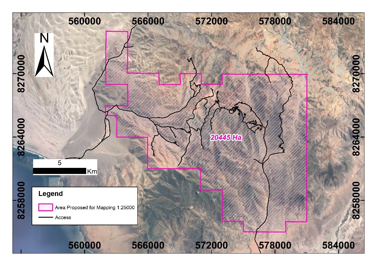
VANCOUVER, BC / ACCESSWIRE / July 26, 2023 / Camino Corp. (TSXV:COR)(OTC PINK:CAMZF)(WKN:A116E1) ("Camino" or the "Company"), together with its project partner Nittetsu Mining Co. Ltd ("Nittetsu"), is pleased to announce that its mapping campaign and drone geophysics survey is underway at the Los Chapitos copper project ("Los Chapitos" or the "Project"). The campaign will focus on copper mineralized structures next to porous geological strata that could host bulk manto-style copper mineralization for follow up exploration drilling. The exploration methodology follows the same geology and geometry of other manto discoveries at Los Chapitos, such as Adriana, Lourdes, and Atajo, to add additional mineral inventory to the Los Chapitos project. Highlights: Geological mapping at a scale of 1:25000 covering 20,445 hectares, emphasizing the understanding of structural geology. Topographic survey covering 15,681 hectares. Drone magnetic geophysical survey covering 5,595 hectares. Picture 1. Topographic survey with WINGTRA Drone with high resolution image capture. "There are many copper outcrop occurrences over the Los Chapitos property, and we have had success at drilling bulk tonnage copper mantos at several copper outcrops such as Adriana and Lourdes", said Jay Chmelauskas, CEO of Camino. "With new geophysics surveys and geology mapping we plan to be more targeted with copper outcrop drilling, and to extend our exploration targets to potential buried copper manto layers. Our overall goal is to add more copper mineralized inventory in the form of additional copper mantos at Los Chapitos." Felix Cornelio, Chief Geologist at Camino stated: "Our 2023 exploration campaign is tapping the experience gained in modelling the copper mantos discovered at Adriana and Lourdes and applying that knowledge to find more copper mantos across the Project. Copper mineralization at Los Chapitos is controlled by geological faults. When a mineralized fault is in contact with a porous geological layer, a bulk tonnage strata-bound copper manto can form in the layer. Thus, we are identifying these geological conditions as targets for our next drilling campaign." The Camino geological team has developed an exploration program that involves a series of geological and geophysical surveys covering 20,445 hectares across the Project's mining concessions. The exploration program will be implemented through geological mapping at a scale of 1:25000 covering the entire Los Chapitos Project area (Figure 1). This work will establish the relationships between faults, host rocks, identification of intrusives, hydrothermal alterations, and styles of mineralization. The purpose is to define prospective zones that could host new mineralized bodies. Figure 1. Los Chapitos Project Area. In parallel to the geological mapping, a topographic survey with drones covering 15,681 hectares and a magnetic geophysical survey covering the NW part of the Project with a total of 5,595 hectares in the North sector of the Atajo Trend will be carried out (Figure 2). Figure 2. Work areas for high-resolution imaging (blue) and proposed magnetometry study (red). About Camino CorporationCamino is a discovery and development stage copper exploration company. The Company is focused on advancing its high-grade Los Chapitos copper project located in Peru through to resource delineation and to add new discoveries. Camino has also permitted the Maria Cecilia copper porphyry project for a planned exploration drilling program. In addition, the Company has increased its land position at its copper and silver Plata Dorada project. The Company seeks to acquire a portfolio of advanced copper assets that have the potential to deliver copper into an electrifying copper intensive global economy. For more information, please refer to Camino's website at www.caminocorp.com. Jose A. Bassan, FAusIMM (CP) 227922, MSc. Geologist, an independent geologist and a Qualified Person as defined by National Instrument 43-101 - Standards of Disclosure for Mineral Projects, has reviewed and approved the technical information in this document. Mr. Bassan has reviewed and verified relevant data supporting the technical information, including sampling and analytical test data. ON BEHALF OF THE BOARD For further information, please contact: /S/ "Jay Chmelauskas" Camino Investor Relations President and CEO info@caminocorp.com Tel: (604) 493-2058 Neither TSX Venture Exchange nor its Regulation Services Provider (as that term is defined in the policies of the TSX Venture Exchange) accepts responsibility for the adequacy or accuracy of this release. Cautionary Note Regarding Forward-Looking Statements: Certain disclosures in this release constitute forward-looking information. In making the forward-looking disclosures in this release, the Company has applied certain factors and assumptions that are based on the Company's current beliefs as well as assumptions made by and information currently available to the Company. Forward-looking information in the release includes the prospectivity of future exploration work at Los Chapitos. Although the Company considers these assumptions to be reasonable based on information currently available to it, they may prove to be incorrect, and the forward-looking information in this release is subject to numerous risks, uncertainties and other factors that may cause future results to differ materially from those expressed or implied in such forward-looking information. Such risk factors include, among others, that actual results of the Company's exploration activities will be different than those expected by management, that the Company will be unable to obtain or will experience delays in obtaining any required approvals and the state of equity and commodity markets. Readers are cautioned not to place undue reliance on forward-looking statements. The Company does not intend, and expressly disclaims any intention or obligation to, update or revise any forward-looking statements whether as a result of new information, future events or otherwise, except as required by law. SOURCE: Camino Minerals Corp. View source version on accesswire.com: https://www.accesswire.com/770302/Camino-Commences-Mapping-and-Drone-Geophysics-Survey-with-Nittetsu-at-the-Los-Chapitos-Project-Peru